|
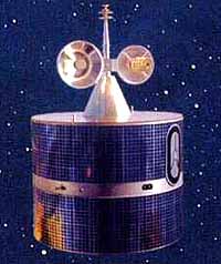
Beijing - June 28, 2000 - On June 25 at 7:50 p.m. Beijing Time a Changzheng-3 (Long March-3) rocket lifted off from the Xichang Satellite Launch Center (XSLC), which is in the southwestern Province of Sichuan. On board was the Fengyun-2B meteorological satellite. Fengyun means "Wind and Cloud. The launch took place at the opening of the launch window, which extended from 7:50 p.m. to 9:27 p.m. reported Xinhua News Agency. Twenty minutes after the on-time launch, tracking data from the Xi'an Satellite Control Centre (XSCC) in the central Shaanxi Province and a Yuanwang tracking vessel indicated that FY-2B reached the predetermined geostationary transfer orbit of 204 km x 36,035 km. The meteorological satellite is expected to reach its orbital slot at 105 deg E longitude over the Equator on July 2. Then there will be a six-month on-orbit checkout of the satellite before it goes into full operation. This is China's second geostationary Metsat. The first of the series, FY-2A, was launched on June 10, 1997. The Shanghai Aerospace Technology Research Institute of the China Aerospace Corporation, the Chinese Research Institute of Space Technology, the No. 18 Electronics Research Institute of the Ministry of Information Industry, the Shanghai Technical Institute of Physics of the Chinese Academy of Sciences and several other research institutes jointly developed the satellite. The cylindrical satellite measures 2.1 m by 1.6 m, and is dual spin-stabilized at a rate of 100 rpm. The main payload of FY-2B is a Visible and Infrared Spin Scan Radiometer (VISSR) which obtains hourly full-disk images of the Earth, through step action of the scan mirror, in three channels: visible (0.55-1.05 micrometer), infrared (10.5-12.5 micrometer) and water vapour (6.2-7.6 micrometer). The visible channel makes observations and derives reflectance of clouds and the Earth surface during daylight hours while the infrared channel senses heat radiation at all times. The water vapour channel measures the amount of water vapour in the middle and upper atmosphere. The subsatellite resolution is 1.25 km for the visible channel and about 5 km for the infrared and water vapour channels. Other functions of FY-2B include monitoring solar activities such as emission of x-ray and particle radiation; collecting and transmitting meteorological, oceanographic and hydrologic data; and broadcasting stretched digital images, low resolution cloud and WEFAX images, synoptic maps and processed products. The National Satellite Meteorological Center (NSMC), a scientific research and operational facility affiliated to the China Meteorological Administration (CMA), receives, processes and distributes data to users. FY-2B incorporates technical improvement from the previous satellite to enhance its reliability and stability. The design lifetime of FY-2B is three years.
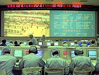
The successful launch was the 13th flight of CZ-3 and the 61st launch for the CZ series. The launch was scheduled to occur between the 24th and 28th. After consulting with the national meteorological administration, the launch centre decided that weather conditions in the evening of the 25th would be the most favourable in this period. Launch preparation started the day before under a cloudy sky and intermittent heavy rain and thunderstorms. At T-8 hours, a go-ahead was given to load the liquid oxygen propellant. The launch team monitored weather radar observations and received hourly weather reports and forecast. At 3 p.m. when the weather forecast suggested that an approaching electrical storm would not arrive at the launch site at the opening of the launch window, the launch team decided to load the liquid hydrogen propellant. Although the cloud deck thickened during the last hours of the countdown, there was no rainfall; much to the relief of the launch team. Then the thick cloud layer thinned out substantially just in time for the launch. At T-10 minutes the rotating service platform swung open, exposing the CZ-3 vehicle. After the launch, a brief celebration took place in rain at the lawn in front of the launch control centre. The launch team lit up firecrackers and congratulated each other with a toast. Community Email This Article Comment On This Article Related Links Space
 Calcutta, India (SPX) Dec 28, 2005
The successful launch Thursday of India's heaviest satellite from spaceport of Kourou in French Guyana may have boosted the country's space research efforts to yet another level, but it has also lifted the spirits of at least three Direct-To-Home televisions broadcasters, one of which has been waiting for years to launch its services in India. |
|
|
|
|
|
|
|
|
|
|
|
|
|
| The content herein, unless otherwise known to be public domain, are Copyright 1995-2006 - SpaceDaily.AFP and UPI Wire Stories are copyright Agence France-Presse and United Press International. ESA PortalReports are copyright European Space Agency. All NASA sourced material is public domain. Additionalcopyrights may apply in whole or part to other bona fide parties. Advertising does not imply endorsement,agreement or approval of any opinions, statements or information provided by SpaceDaily on any Web page published or hosted by SpaceDaily. Privacy Statement |