|
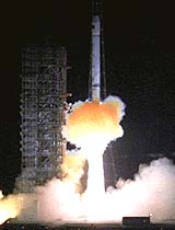
Beijing - Cot. 31, 2000 China successfully launched its first navigation positioning satellite, the official Xinhua News Agency reported earlier today (Oct. 31). While the world watched intently the final day of preparing the historic launch of the first resident crew to the International Space Station, China quietly slipped the domestically built navigation positioning satellite, Beidou Navigation Test Satellite-1 (BNTS-1; "Beidou" means "Northern Dipper", a reference to the celestial constellation), into orbit. A Changzheng-3A (Long March-3A) rocket lifted off from the Xichang Satellite Launching Center (XSLC) in the southwest Sichuan Province at 2 minutes past midnight Beijing Time (16:02 UTC October 30). The launcher roared through the night sky and "precisely delivered the satellite to its predetermined orbit" 27 minutes later. Xinhua did not disclose details of the satellite and orbital parameters in the initial dispatch. According to Xinhua the Space Technology Research Institute, one of the five major research institutions of the China Aerospace Science and Technology Corporation (CASC), developed and built BNTS-1. CASC leads the effort to develop China's first generation satellite navigation and positioning system, the Beidou Navigation System (BNS). The system will meet the increasing domestic demands of satellite navigation. CASC said that the navigation system would be an "all-weather, all-time operation" which delivers regional satellite navigation information. When the system is completed, BNS will be used primarily in highway and railway transportation and seafaring. A CASC official said, "The successful launch of BNTS-1 lays the foundation to establish the Beidou Navigation System." The launch was the 63rd flight of the Changzheng series of rockets and the 21st consecutive successful launch since October 1996. Among the observers at the launch center were representatives from the military branch, including Cao Gangchuan, Director of the General Armament Department of the People's Liberation Army and a member of the Central Military Commission. His presence signifies the importance of the navigation and positioning system to future Chinese military operations. The launch came just a week after the Hong Kong-based newspaper Wen Wei Po reported last Monday (Oct. 23) that China would achieve a major breakthrough in satellite navigation in the near future. The newspaper cited an unidentified source that after years of research and development, China had made significant progress in a GPS-type system, a reference to the American Global Positioning Satellite system, and a major breakthrough was imminent. The source said that navigation and positioning satellite development would be among the three major application satellite work that China would focus on in the beginning of the 21st century. The other two major application satellite projects are remote sensing and communications satellites. To lay the groundwork of producing equipment to receive signals from the Beidou Navigation System in the future, China has also developed and built commercial receiver of current GPS signals. In early September, Xinhua reported that the first domestically developed multifunction satellite navigator entered production. The navigator, developed by FAW Group in Changchun in the northeastern Jilin Province, went into production in Anshan in the neighbouring Liaoning Province. The navigator would be incorporated into selected models of Chinese-made sedans. In addition to navigation and positioning, the small and lightweight navigator has over 20 different functions such as in inquiring address and information, and measuring distances. Community Email This Article Comment On This Article Related Links SpaceDaily Search SpaceDaily Subscribe To SpaceDaily Express GPS Applications, Technology and Suppliers
 San Jose CA (SPX) Jan 04, 2006
Continuing to drive GPS further into the mainstream market, SiRF Technology Holdings has revealed that its flagship SiRFstarIII GPS technology is at the heart of TomTom's RIDER, a high performance portable navigation system specifically designed for use on motorcycles and scooters. TomTom is a leading provider of personal navigation products and services to the US and European consumer markets. |
|
|
|
|
|
|
|
|
|
|
|
|
|
| The content herein, unless otherwise known to be public domain, are Copyright 1995-2006 - SpaceDaily.AFP and UPI Wire Stories are copyright Agence France-Presse and United Press International. ESA PortalReports are copyright European Space Agency. All NASA sourced material is public domain. Additionalcopyrights may apply in whole or part to other bona fide parties. Advertising does not imply endorsement,agreement or approval of any opinions, statements or information provided by SpaceDaily on any Web page published or hosted by SpaceDaily. Privacy Statement |