|
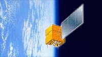
Beijing - February 3, 2000 - The recently launched China-Brazil remote sensing satellite has a clean bill of health reports the official Chinese news agency Xinhua. The China-Brazil Earth Resources Satellite (CBERS-1), also called Ziyuan-1 (ZY-1) in Chinese ("Ziyuan" means resource), was launched on October 14 last year from the Taiyuan Satellite Launch Center in the northern Shanxi Province. A Long March-4B rocket placed the satellite into a polar sun-synchronous orbit of about 780 km. The satellite is controlled from the Xian Satellite Control Centre. According to the Chinese Academy of Space Technology, the Chinese partner in the project, ZY-1 has completed all on-orbit tests and will go into operation soon. The satellite, with a mass of 1540 kg, has a life expectancy of two years. ZY-1 completes 14 orbits each day, and repeats its ground tracks every 26 days. Since launch, ZY-1 has completed more than 1500 orbits. This is a joint production of China and Brazil's National Institute for Space Research (INPE) with China responsible for 70% of the cost said Chen Yiyuan, head designer of ZY-1. Remote sensing images and data transmitted to China, Brazil and other countries will be used in resources, environment and disaster monitoring and assessment such as water quality, weather, deforestation, underground resource exploration, proper exploitation monitoring, urban planning and growth trends and production monitoring in agriculture. ZY-1 carries three sensors:
The replacement of this satellite, CBERS-2, is planned for a 2001 launch.
Email This Article Comment On This Article Related Links Space
 Calcutta, India (SPX) Dec 28, 2005
The successful launch Thursday of India's heaviest satellite from spaceport of Kourou in French Guyana may have boosted the country's space research efforts to yet another level, but it has also lifted the spirits of at least three Direct-To-Home televisions broadcasters, one of which has been waiting for years to launch its services in India. |
|
|
|
|
|
|
|
|
|
|
|
|
|
| The content herein, unless otherwise known to be public domain, are Copyright 1995-2006 - SpaceDaily.AFP and UPI Wire Stories are copyright Agence France-Presse and United Press International. ESA PortalReports are copyright European Space Agency. All NASA sourced material is public domain. Additionalcopyrights may apply in whole or part to other bona fide parties. Advertising does not imply endorsement,agreement or approval of any opinions, statements or information provided by SpaceDaily on any Web page published or hosted by SpaceDaily. Privacy Statement |