|
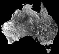
Saint-Hubert - July 16, 2001 A mosaic of Australia taken by Radarsat-1, the renowned Synthetic Aperture Radar (SAR) satellite operated by the Canadian Space Agency (CSA), was presented today to conference delegates attending the International Geoscience and Remote Sensing Symposium (IGARSS) in Sydney, Australia. "The absolutely outstanding results of the Australia mosaic," said Surendra Parashar, CSA Director of Satellite Operations, "reaffirms our commitment to pursue similar projects that will continue to enhance the knowledge, understanding and protection of our global resources and environment." The Australia mosaic, a compilation of 165 images captured from mid-November 2000 to mid-February 2001 demonstrates the timely and detailed observation capacity of Radarsat-1 and the expertise of Radarsat International who, in a joint project with the CSA, processed the high-resolution data required to create the Australia mosaic. "We are very happy to have worked with the CSA to produce this mosaic. By creating the mosaic of Australia we now have a "baseline" from the winter 2000-2001 against which users can perform future change detection studies. For example, the mosaic can be used as a reference point to look at changes in urbanization, desert encroachment and coastline morphology", said Roland Knight, President of Radarsat International. Radarsat-1 provides Canada and the world with an operational radar satellite system capable of delivering timely and critical data to assist disaster relief and emergency rescue efforts while also delivering the information required by commercial and scientific users in the fields of agriculture, cartography, hydrology, forestry, oceanography, ice studies and coastal monitoring. The first such map ever produced of Australia by an Earth Observation satellite, the Australia mosaic is part of an on-going project of the Canadian Space Agency, which has generated the production of mosaics of Antarctica, Canada, the United States and now Australia. Currently underway is the comprehensive data mapping of Africa which is projected for completion in 2002. Community Email This Article Comment On This Article Related Links Full Res Images - slow loading via browser Radarsat International SpaceDaily Search SpaceDaily Subscribe To SpaceDaily Express Dirt, rocks and all the stuff we stand on firmly
 Paris (ESA) Jan 12, 2006
Using the ESA Cluster spacecraft and the NASA Wind and ACE satellites, a team of American and European scientists have discovered the largest jets of particles created between the Earth and the Sun by magnetic reconnection. This result makes the cover of this week's issue of Nature. |
|
|
|
|
|
|
|
|
|
|
|
|
|
| The content herein, unless otherwise known to be public domain, are Copyright 1995-2006 - SpaceDaily.AFP and UPI Wire Stories are copyright Agence France-Presse and United Press International. ESA PortalReports are copyright European Space Agency. All NASA sourced material is public domain. Additionalcopyrights may apply in whole or part to other bona fide parties. Advertising does not imply endorsement,agreement or approval of any opinions, statements or information provided by SpaceDaily on any Web page published or hosted by SpaceDaily. Privacy Statement |