 |
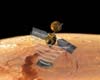
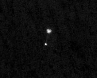
Pasadena CA (JPL) May 26, 2008 A telescopic camera in orbit around Mars caught a view of NASA's Phoenix Mars Lander suspended from its parachute during the lander's successful arrival at Mars Sunday evening, May 25. The image from the High Resolution Imaging Science Experiment (HiRISE) on NASA's Mars Reconnaissance Orbiter marks the first time ever one spacecraft has photographed another one in the act of landing on Mars. Meanwhile, scientists pored over initial images from Phoenix, the first ever taken from the surface of Mars' polar regions. Phoenix returned information that it was in good health after its first night on Mars, and the Phoenix team sent the spacecraft its to-do list for the day. "We can see cracks in the troughs that make us think the ice is still modifying the surface," said Phoenix Principal Investigator Peter Smith of the University of Arizona, Tucson. "We see fresh cracks. Cracks can't be old. They would fill in." Camera pointing for the image from HiRISE used navigational information about Phoenix updated on landing day. The camera team and Phoenix team would not know until the image was sent to Earth whether it had actually caught Phoenix. "We saw a few other bright spots in the image first, but when we saw the parachute and the lander with the cords connecting them, there was no question," said HiRISE Principal Investigator Alfred McEwen, also of the University of Arizona. "I'm floored. I'm absolutely floored," said Phoenix Project Manager Barry Goldstein of NASA's Jet Propulsion Laboratory, Pasadena, Calif. A team analyzing what can be learned from the Phoenix descent through the Martian atmosphere will use the image to reconstruct events. HiRISE usually points downward. For this image, the pointing was at 62 degrees, nearly two-thirds of the way from straight down to horizontal. To tilt the camera, the whole orbiter must tilt. Mars Reconnaissance Orbiter was already pointed toward the expected descent path of Phoenix to record radio transmissions from Phoenix. McEwen said, "We've never taken an image at such an oblique angle before." Monday's tasks for Phoenix include checkouts of some instruments and systems, plus additional imaging of the lander's surroundings. Community Email This Article Comment On This Article Share This Article With Planet Earth
Related Links Phoenix at LPL Phoenix at NASA http://mars.jpl.nasa.gov/mro/ Mars News and Information at MarsDaily.com Lunar Dreams and more
 Rome, Italy (SPX) May 26, 2008
The radar sounder SHARAD of the NASA mission Mars Reconnaissance Orbiter has provided images of the Mars North Pole stratigraphy. |
|
| The content herein, unless otherwise known to be public domain, are Copyright 1995-2007 - SpaceDaily.AFP and UPI Wire Stories are copyright Agence France-Presse and United Press International. ESA Portal Reports are copyright European Space Agency. All NASA sourced material is public domain. Additional copyrights may apply in whole or part to other bona fide parties. Advertising does not imply endorsement,agreement or approval of any opinions, statements or information provided by SpaceDaily on any Web page published or hosted by SpaceDaily. Privacy Statement |
 del.icio.us
 Digg
Digg Reddit
 YahooMyWeb
 Google