|
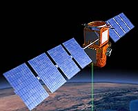
Paris (SPX) May 20, 2005 The climatology satellite Calipso (Cloud-Aerosol Lidar and Infrared Pathfinder Satellite Observations) left Alcatel Space, a subsidiary of Alcatel, plant in Cannes (southern France) during the night of May 18 for transport to the Vandenberg Air Force Base and spaceport in California. Launch is scheduled for this summer on a Delta 2 launcher, along with the Cloudsat satellite. Calipso will help scientists understand the Earth's climatic system and predict global changes, an ability limited until now by uncertainty about the radiation impact of clouds and aerosols. It will supply a unique set of data on vertical atmosphere profiles, using the first satellite-mounted backscatter lidar (LIght Detection And Ranging). This climatology mission, designed to support the sustainable development of our planet, is a joint program of NASA and French space agency CNES, with Alcatel Space and Ball Aerospace as the main industry partners. Calipso is part of a global climate study program and will be flying in formation with two American missions, Aqua and Cloudsat, along with the French microsatellite, Parasol. This will form an exceptional space observatory, the "A-train", combining all active and passive measurement techniques and positioned in sun-synchronous orbit at an altitude of 705 kilometers. Aqua was launched in April 2002 and has a design life of five years. Parasol was launched on December 18, 2004. Calipso is the second application for the Proteus platform developed by Alcatel in conjunction with CNES. Following the Jason-1 oceanographic altimetry satellite, which celebrated the third anniversary of a very successful mission last December. The Poseidon altimeter on the Jason-1 satellite delivers a constant stream of essential oceanography data. Community Email This Article Comment On This Article Related Links Alcatel Space SpaceDaily Search SpaceDaily Subscribe To SpaceDaily Express Earth Observation News - Suppiliers, Technology and Application
 New York NY (SPX) Jan 11, 2006
The importance of remotely sensed data and technologies to support natural disasters has prompted attention and action in Washington. New initiatives and legislation authorizing appropriations to the remote sensing industry will be discussed at Strategic Research Institute's U.S. Commercial Remote Sensing Industry conference, scheduled for February 9-10, 2006 in Washington D.C. |
|
| The content herein, unless otherwise known to be public domain, are Copyright 1995-2006 - SpaceDaily.AFP and UPI Wire Stories are copyright Agence France-Presse and United Press International. ESA PortalReports are copyright European Space Agency. All NASA sourced material is public domain. Additionalcopyrights may apply in whole or part to other bona fide parties. Advertising does not imply endorsement,agreement or approval of any opinions, statements or information provided by SpaceDaily on any Web page published or hosted by SpaceDaily. Privacy Statement |