|
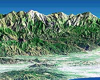
Pasadena - Jan 22, 2002 Displaying spectacular new 3-D images and animations of California from space, scientists at NASA's Jet Propulsion Laboratory, Pasadena, Calif., today announced the release of high-resolution topographic data of the continental United States gathered during the February 2000 Shuttle Radar Topography Mission -- a mission that is creating the world's best topographic map. "The release of the California mosaic and continental- U.S. Shuttle Radar Topography Mission data is a tantalizing preview of things to come from this program," said Dr. Michael Kobrick, mission project scientist at JPL. "We are processing data for the rest of the world on a continent-by-continent basis, mapping and exploring many relatively unknown regions where our maps will be far more precise than the best global maps in use today." Dr. Yunjin Kim, mission project manager at JPL, said users in the United States and elsewhere would find wide applications for the data. "The maps produced from the mission will be among the most valuable, universally beneficial data ever produced by a science mission. "National and local government organizations, scientists, commercial enterprises and civilians alike will find the data useful for applications as diverse as earthquake studies, flood control, transportation and urban planning, enhanced ground-collision warning systems for aircraft and better placement of cell phone towers," he explained. With today's release, gigabytes of digital elevation- model data, sampled at an interval of one measurement every 30 meters (98 feet), are now available to selected science investigators, with 90-meter (295-foot) sample imagery available to the public. Processing and distribution of validated U.S. digital topographic data will continue on a regular basis, with completion expected this spring. When completed in fall 2002, more than 12 terabytes of data encompassing nearly 1 trillion measurements will have been processed, representing the 80 percent of Earth's landmass between 60 degrees north and 56 degrees south of the equator. The areas mapped are home to approximately 95 percent of the world's population. Thomas A. Hennig, mission program manager at the National Imaging and Mapping Agency, said, "The Shuttle Radar Topography Mission literally captured a snapshot of the Earth's surface at the beginning of the 21st century that will be of tremendous value for years to come. The data from this mission will provide the agency's customers a revolutionary leap forward in imaging information." The agency partnered with NASA, Germany and Italy in sponsorship of the mission. The centerpiece of today's release is the California mosaic, a color-shaded relief elevation map. The image depicts California at a data-sample interval of 3 arc-seconds (approximately 90 meters or 295 feet). The map depicts changes in height as colors, with blues and greens at the lower elevations, rising through yellows and browns to white at the highest elevations. As processing of each continent is finished, data will be sent to the National Imaging and Mapping Agency for final quality checking and copies sent to the United States Geological Survey's Earth Resources Observation Systems Data Center, Sioux Falls, S.D., for final archiving and distribution. The Shuttle Radar Topography Mission was flown aboard Space Shuttle Endeavour February 11-22, 2000. It used modified versions of the same instruments that comprised the Space Shuttle Imaging Radar-C/X-Band Synthetic Aperture Radar that flew twice on Endeavour in 1994. The mission collected 3-D measurements of Earth's land surface using radar interferometry, which compares two radar images taken at slightly different locations to obtain elevation or surface-change information. To collect the data, engineers added a 60-meter (approximately 200-foot) mast, installed additional C-band and X-band antennas, and improved tracking and navigation devices. The Shuttle Radar Topography Mission supports NASA's Earth Science Enterprise, Washington, D.C., a long-term research and technology program designed to examine Earth's land, oceans, atmosphere, ice and life as a total integrated system. Community Email This Article Comment On This Article Related Links California Image Library - Direct Link Caption Page for Above Images SpaceDaily Search SpaceDaily Subscribe To SpaceDaily Express Dirt, rocks and all the stuff we stand on firmly
 Paris (ESA) Jan 12, 2006
Using the ESA Cluster spacecraft and the NASA Wind and ACE satellites, a team of American and European scientists have discovered the largest jets of particles created between the Earth and the Sun by magnetic reconnection. This result makes the cover of this week's issue of Nature. |
|
| The content herein, unless otherwise known to be public domain, are Copyright 1995-2006 - SpaceDaily.AFP and UPI Wire Stories are copyright Agence France-Presse and United Press International. ESA PortalReports are copyright European Space Agency. All NASA sourced material is public domain. Additionalcopyrights may apply in whole or part to other bona fide parties. Advertising does not imply endorsement,agreement or approval of any opinions, statements or information provided by SpaceDaily on any Web page published or hosted by SpaceDaily. Privacy Statement |