|
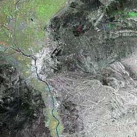
Paris, France (ESA) Nov 29, 2004 This multi-coloured composite Envisat radar image is focused over Egypt's capital city of Cairo, and shows the Nile running from south to north. Cairo has an overall metropolitan area population of 15 million. It is the largest city in Africa and the thirteenth largest city in the world. Also visible is Cairo International Airport, to the northeast of the city � visible as two thick black lines. West of Cairo's southwest suburb of Giza are found the trio of Egypt's famous pyramids, the Great Pyramid of Khufu or Cheops, the Khafre Pyramid and the Menkaure Pyramid. These show a visible radar signature looking at the image in full-size mode. The image highlights the fertile territories of the region, with green representing vegetation growth occurring during the winter season. Growth is concentrated in particular along the valley of the River Nile and the Nile Delta, located in the top left segment of the image. The Delta is an important agricultural region supporting a dense population. Radar images measure surface roughness rather than reflected light. The colour in the image comes from the fact that this is actually a combination of three Envisat Advanced Synthetic Aperture Radar (ASAR) wide swath mode precision images, and is used to highlight changes occurring between acquisitions. A colour is assigned to each date of acquisition: red for 7 June 2004, green for 20 November 2003 and blue for 8 April 2004, with a spatial resolution of 12.5 metres. Community Email This Article Comment On This Article Related Links Envisat SpaceDaily Search SpaceDaily Subscribe To SpaceDaily Express Earth Observation News - Suppiliers, Technology and Application
 New York NY (SPX) Jan 11, 2006
The importance of remotely sensed data and technologies to support natural disasters has prompted attention and action in Washington. New initiatives and legislation authorizing appropriations to the remote sensing industry will be discussed at Strategic Research Institute's U.S. Commercial Remote Sensing Industry conference, scheduled for February 9-10, 2006 in Washington D.C. |
|
| The content herein, unless otherwise known to be public domain, are Copyright 1995-2006 - SpaceDaily.AFP and UPI Wire Stories are copyright Agence France-Presse and United Press International. ESA PortalReports are copyright European Space Agency. All NASA sourced material is public domain. Additionalcopyrights may apply in whole or part to other bona fide parties. Advertising does not imply endorsement,agreement or approval of any opinions, statements or information provided by SpaceDaily on any Web page published or hosted by SpaceDaily. Privacy Statement |