|
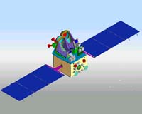
Delhi, India (SPX) May 04, 2005 In its ninth flight, ISRO's Polar Satellite Launch Vehicle, PSLV-C6, will launch India's remote sensing satellite, the 1,560 kg CARTOSAT-1, along with a 42.5 kg piggyback satellite, HAMSAT, in a 618 km polar Sun Synchronous Orbit (SSO). For the first time, the state-of-the-art Second Launch Pad at Satish Dhawan Space Centre (SDSC) SHAR is being used for a launch. PSLV was initially designed by ISRO to place 1,000 kg class Indian Remote Sensing (IRS) satellites into 900 km polar Sun-synchronous Orbits. Since the first successful flight in October 1994, the capability of PSLV has been enhanced from 850 kg to the present 1,600 kg into 618 km polar Sun Synchronous Orbit. The improvement in the capability over successive flights has been achieved through several means. They include increased propellant loading in the stage motors, employing composite material for the satellite mounting structure and changing the sequence of firing of the strap-on motors. In its present configuration, the 44.4 metre tall, 295 tonne PSLV has four stages using solid and liquid propulsion systems alternately. The first stage, carrying 138 tonne of propellant, is one of the largest solid propellant boosters in the world. Six solid propellant strap-on motors, each carrying nine tonne of solid propellant, are strapped on to the core stage. The second stage carries 41.5 tonne of liquid propellant. The third stage uses 7.6 tonne of solid propellant and the fourth has a twin engine configuration with 2.5 tonne of liquid propellant. The 3.2 metre diameter metallic bulbous heat shield protects the satellites and it is discarded after the vehicle has cleared the dense atmosphere. PSLV employs a large number of auxiliary systems for stage separation, heat-shield separation and so on. It has sophisticated systems to control the vehicle and guide it through the predetermined trajectory. The vehicle performance is monitored through telemetry and tracking. With seven consecutively successful flights so far, PSLV has proved itself as a reliable workhorse. It has demonstrated multiple satellite launch capability having launched four small satellites for international customers besides seven Indian satellites. PSLV was used to launch ISRO's exclusive meteorological satellite, KALPANA-1, into a Geo-synchronous Transfer Orbit (GTO) in September 2002. The vehicle will be used to launch a spacecraft for India's first mission to Moon, Chandrayaan-1. Vikram Sarabhai Space Centre (VSSC), Thiruvananthapuram, designed and developed PSLV. The ISRO Inertial Systems Unit (IISU) at Thiruvananthapuram developed the inertial systems for the vehicle. The Liquid Propulsion Systems Centre (LPSC), also at Thiruvananthapuram, developed the liquid propulsion stages for the second and fourth stages of PSLV as well as reaction control systems. SDSC SHAR processed the solid motors and carried out launch operations. ISRO Telemetry, Tracking and Command Network (ISTRAC) provides telemetry, tracking and command support. Second Launch Pad (SLP) SLP built at SDSC SHAR at Sriharikota is a state-of-the-art launch complex. SLP is configured as a universal launch pad capable of accommodating all the vehicles of ISRO including the advanced launch vehicle to be built in the next decade and beyond (unlike dedicated pads elsewhere in the world mainly catering to a particular launch vehicle). SLP uses integrate-transfer-and-launch concept. The launch vehicle is integrated inside a permanent building called Vehicle Assembly Building (VAB). After checkout, it is transported on rails to the launch pad using a Mobile Launch Pedestal (MLP). The vehicle is then interfaced with the launch pedestal and fuel-filling and checkout operations carried out. The launch takes place after the final countdown. SLP helps to increase the launch frequency by reducing the turn-around time between the integration of the fully assembled vehicles. SLP was built by involving Indian industry on a turnkey basis including design and engineering, procurement of systems and sub-systems, fabrication, erection and commissioning of facilities including civil works. SLP consists of the following major elements: Vehicle Assembly Building (VAB): It is in this building that the vehicle integration is carried out on a Mobile Launch Pedestal (MLP) and then the vehicle transferred to Umbilical Tower for launch after carrying out the total checkout of the integrated vehicle. The 82 m tall VAB houses 200 tonne and 30 tonne capacity cranes for lifting vehicle stages. It has 20 horizontal sliding doors of varying sizes with the largest being 13 x 20 m. Six 14 x 6 m foldable and vertically repositionable platforms at different levels help vehicle integration and servicing. VAB is equipped with an elevator also. Mobile Launch Pedestal (MLP): The 19.5 x 19.5 m MLP with bogie system is used to transfer the integrated vehicle from VAB to the launch pad located at a distance of 1 km. With a height 8.6 m, MLP weighs about 700 tonne and caters for both PSLV and GSLV requirements. It has a removable bogie system at the bottom, which has a hydraulic system. Umbilical Tower (UT): The 70 m tall, 10 x 10 m UT weighs about 980 tonne. The fully integrated vehicle on MLP, on its arrival on rails, is interfaced with the UT with electrical, pneumatic and fluid filling lines. The final operations like fuel filling, gas charging and the vehicle checkout are carried out on UT. It has three platforms, which can be swung and also moved vertically to different levels. UT has an elevator and a 10 tonne tower crane at the top of the tower. It has a cryo arm for cryogenic fuel filling operations and monitoring till the last minute of launch operations. Jet Deflector: The jet deflector system is used to move the hot gases, ejected from the launcher during lift-off, away from the launch pad so as to reduce the thermal and acoustic loads on the vehicle. The design and construction of jet deflector was one of the major engineering challenges. It has diaphragm wall construction with piles driven 45 m below ground, constructed for the first time on the east coast of India. Lightning Protection Towers: In order to protect the launch vehicle from severe lightning when the vehicle is exposed for longer duration, lightning protection towers are erected around UT. There are four lightening protection towers of 120 m height around UT, which are interconnected through cables. Propellant Storage and Servicing Facilities: Propellant storage and servicing facilities cater to storage of about 1000 tonne of earth storable propellants (UDMH and N2O4), cryogenic propellants (liquid Oxygen and liquid Hydrogen), water, etc. A large gas storage and supply system to supply the required quantity of Helium for on-board systems and Nitrogen system for meeting the purging requirements is part of this facility. A water tank of 5 lakh litre capacity is also included. Utilities: These include instrumentation and control systems, compressed air and fire fighting system, overhead tank, water treatment plant, electrical substation, air conditioning plant and safety system. Track for Movement of MLP: MLP with the integrated vehicle moves on a twin double rail track with a span of 14 m and a length of 1 km. About CARTOSAT-1 CARTOSAT-1 is the eleventh satellite in the Indian Remote Sensing satellite series. It is a state-of-the art remote sensing satellite built by ISRO. Weighing 1560 kg at lift-off, CARTOSAT-1 is intended for cartographic applications. The satellite will be launched into a 618 km high polar Sun Synchronous Orbit. CARTOSAT-1 carries two state-of-the-art Panchromatic cameras that take black-and-white stereoscopic pictures in the visible region of the electromagnetic spectrum. The imageries will have a spatial resolution of 2.5 metre. The cameras cover a swath of 30 km and they are mounted in such a way that near simultaneous imaging of the same area from two different angles is possible. This facilitates in generating three-dimensional maps. The cameras are steerable across the direction of satellite's movement to facilitate the imaging of an area more frequently. CARTOSAT-1 also carries a Solid State Recorder with a capacity of 120 Giga Bits to store the images taken by its cameras. These images can later be transmitted when the satellite comes within the visibility of a ground station. Soon after its injection into orbit, the two solar panels of CARTOSAT-1 are deployed. The satellite health will be continuously monitored from the Spacecraft Control Centre at Bangalore with the help of ISTRAC network of stations at Bangalore, Lucknow, Mauritius, Bearslake in Russia and Biak in Indonesia. Community Email This Article Comment On This Article Related Links ISRO SpaceDaily Search SpaceDaily Subscribe To SpaceDaily Express Earth Observation News - Suppiliers, Technology and Application
 New York NY (SPX) Jan 11, 2006
The importance of remotely sensed data and technologies to support natural disasters has prompted attention and action in Washington. New initiatives and legislation authorizing appropriations to the remote sensing industry will be discussed at Strategic Research Institute's U.S. Commercial Remote Sensing Industry conference, scheduled for February 9-10, 2006 in Washington D.C. |
|
| The content herein, unless otherwise known to be public domain, are Copyright 1995-2006 - SpaceDaily.AFP and UPI Wire Stories are copyright Agence France-Presse and United Press International. ESA PortalReports are copyright European Space Agency. All NASA sourced material is public domain. Additionalcopyrights may apply in whole or part to other bona fide parties. Advertising does not imply endorsement,agreement or approval of any opinions, statements or information provided by SpaceDaily on any Web page published or hosted by SpaceDaily. Privacy Statement |