|
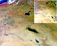
Paris - Sep 15, 2003 12 September 2003 A burning oil pipeline in northern Iraq produced an immense cloud of black smoke that stretched across thousands of square kilometres, in this image acquired by Envisat�s Medium Resolution Imaging Spectrometer. The smoke cloud is visible in the centre of this image of the alluvial plain occupied by the valley of the river Tigris (flowing from the top centre of the image) and the Euphrates (flowing from the top left corner). The Medium Resolution Imaging Spectrometer (MERIS) on ESA�s Envisat environmental satellite acquired the image on 30 August, the same day as the media reported a fire affecting a segment of oil pipeline near the town of Hawija. The pipeline transports crude oil from the oil-rich city of Kirkuk � seen here in grey, on the Tigris River - to Baija, where the country�s largest oil refinery is located. For comparison the second MERIS image shows the same area three days earlier, before the pipeline had been damaged. The dense cloud of smoke has an extent comparable to the Iranian lake Urmia (which has an area of 4700 square kilometres), seen in turquoise colour towards the top right of the image. Authorities stated it took two days to bring the fire under control. These three-band MERIS images have a resolution of 1200 metres and were processed by Hamburg-based Brockmann Consult. Community Email This Article Comment On This Article Related Links SpaceDaily Search SpaceDaily Subscribe To SpaceDaily Express Earth Observation News - Suppiliers, Technology and Application
 New York NY (SPX) Jan 11, 2006
The importance of remotely sensed data and technologies to support natural disasters has prompted attention and action in Washington. New initiatives and legislation authorizing appropriations to the remote sensing industry will be discussed at Strategic Research Institute's U.S. Commercial Remote Sensing Industry conference, scheduled for February 9-10, 2006 in Washington D.C. |
|
| The content herein, unless otherwise known to be public domain, are Copyright 1995-2006 - SpaceDaily.AFP and UPI Wire Stories are copyright Agence France-Presse and United Press International. ESA PortalReports are copyright European Space Agency. All NASA sourced material is public domain. Additionalcopyrights may apply in whole or part to other bona fide parties. Advertising does not imply endorsement,agreement or approval of any opinions, statements or information provided by SpaceDaily on any Web page published or hosted by SpaceDaily. Privacy Statement |