|
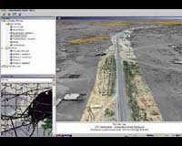
Fort Belvoir VA (AFNS) Jun 15, 2006 A system initially adopted to help the Army Corps of Engineers detect invasive vegetation growing in coastal waterways is giving warfighters an edge in the global war on terror. "Buckeye," a digital imaging system that's installed on an aircraft, gives ground commanders a bird's-eye view of the area in which they're operating, Army Capt. Jed Richards, research and development coordinator for the Army's Topographic Engineering Center here, told American Forces Press Service. Featuring a high-quality digital camera with an extra-large focal frame, Buckeye "looks" nearly straight down from an aircraft and captures images of the area below. Analysts on the ground eliminate any distortions as they combine these multiple shots into one extra-large image, Richards explained. These overlapping images create a "stereoscopic pair" that enables viewers wearing special polarized glasses to see the image in three dimensions, said Michael Tischler, a physical scientist here. "So when you do this for an entire city, you create a series of three-dimensional images," he said. The Army Corps of Engineers, the U.S. government's civil-works arm, initially tapped into this capability to identify nonnative plant growth before it began choking coastal areas. But its workers quickly recognized Buckeye's adaptability to its combat-support mission as well. Buckeye has "a zillion applications" for warfighters, Tischler said. For example, the system's 3D capability, provided in a detailed map that includes grid coordinates, gives troops a level of situational awareness simply not possible from standard overhead imagery. "And there are a lot of benefits to that," Tischler said. "You are able to see heights, the lay of the land, (and) you are able to plan better. You're able to get a better idea of what is there." Troops can use it to rehearse patrols through areas where they've never been and identify potential sniper locations, evaluating them via a laptop computer or a hard-copy printout. "If you're getting a briefing before moving into a city, you can look at this and say, 'This is the route we'll take in, and these are the critical points as we move along,'" Richards said. But unlike a traditional map, Buckeye enables troops to evaluate their operating area from different vantage points. "So if I'm on top of a building, this is the view I have," Richards said, pointing to a Buckeye image from an Iraqi city. "This is the city I lived in for six months," he said. "And before I drove in, I had no idea what to expect. But if I had seen this image, it would have been a huge benefit. This gives incoming units a familiarization with the area before they ever hit the ground." Troops on the ground are giving Buckeye a resounding thumbs up. "The feedback we're getting from the field is that they're using it and loving it," Richards said. The first Buckeye system deployed to Iraq in November 2004, where the 1st Stryker Brigade, 25th Infantry Division, from Fort Lewis, Wash., put it through its first combat application. Multinational Corps Iraq got its own Buckeye system in November 2005, and the 101st Airborne Division (Air Assault) is currently operating it. The 10th Mountain Division, in Afghanistan, got the Buckeye system in late May. Buckeye's simple design -- basically a camera, gyroscope and computer processor -- and the fact that it needs only a pilot, operator and processor to operate makes it a simple, low-cost tool for the terror war, Richards said. "The troops on the ground really appreciate the resolution and the capability of this data set," he said. "It's giving new capabilities to the warrior." Community Email This Article Comment On This Article Related Links - The latest in Military Technology for the 21st century at SpaceWar.com
 Montville NJ (SPX) Jun 15, 2006
Marotta Controls announced today that it has been selected by NAVAIR to build high-pressure pneumatic Pure Air Generating Systems for integration into the LAU-7 and LAU-127 missile rail launchers using its proprietary Pure Air Compression Technology, M-PACT. |
|
| The content herein, unless otherwise known to be public domain, are Copyright 1995-2006 - SpaceDaily.AFP and UPI Wire Stories are copyright Agence France-Presse and United Press International. ESA PortalReports are copyright European Space Agency. All NASA sourced material is public domain. Additionalcopyrights may apply in whole or part to other bona fide parties. Advertising does not imply endorsement,agreement or approval of any opinions, statements or information provided by SpaceDaily on any Web page published or hosted by SpaceDaily. Privacy Statement |