|
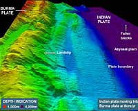
London (AFP) Feb 09, 2005 The British Navy surveying the seabed at the epicenter of December's Indian Ocean earthquake released its first images Wednesday that indicate a landslide occurred where two plates came together in a ridge. The Royal Navy's HMS Scott has been taking underwater sonar readings off the Indonesian island of Sumatra to try to find out how the December 26 earthquake unfolded and then produced the giant waves that have killed nearly 300,000 people in 11 countries. The colored digital mapping, displayed at the United Kingdom Hydrographic Office in Taunton, Somerset, showed a large landslide some 100 metres high by two kilometres in length. HMS Scott's Commanding Officer Steve Malcolm said initial assessments by scientists indicate two of the earth's tectonic plates came together, causing a ridge on the seabed which forced sea water to travel upwards to form the devastating tsunami. They must have clashed "like the rumpling up of a carpet," he said. He said he hoped the survey would give a warning as to when this could happen again "with the aim of removing the likelihood of such a terrible loss of life". HMS Scott's survey will provide the "base map" for future extensive research into the process of how earthquakes work and how they produce tsunamis. Data will help produce charts to build a picture of what happened on December 26 and what might happen next. The commander said it was hoped the Indonesian government would permit the release of as much information as possible to the wider local community "to give warning to prevent such a tragedy happening again". He said the survey, which began in late January, and its images, though unable to give exact predictions of when earthquakes will occur, could indicate a level of risk. The depth of the water in the area of the epicenter varies between 200 and 5,000 meters (670 and 16,700 feet), all of which is within the HMS Scott's capability, scientists say. The epicenter of the quake, which measured a massive 9.0 on the Richter scale, lies within the Indonesian Exclusive Economic Zone. The survey will fall under the definition of Marine Scientific Research under the United Nations Convention on Law of the Sea. HMS Scott sailed from Plymouth's Devonport Naval Base in November last year to undertake a program of military-based data gathering in the North Atlantic, Arabian Sea and Indian Ocean. Community Email This Article Comment On This Article Related Links SpaceDaily Search SpaceDaily Subscribe To SpaceDaily Express Tectonic Science and News
 Sydney (AFP) Dec 12, 2005
Thousands of tonnes of ash are continuing to spew from a volcano in Vanuatu, but officials said Monday the activity on the South Pacific nation was not likely to result in a major deadly eruption. |
|
| The content herein, unless otherwise known to be public domain, are Copyright 1995-2006 - SpaceDaily.AFP and UPI Wire Stories are copyright Agence France-Presse and United Press International. ESA PortalReports are copyright European Space Agency. All NASA sourced material is public domain. Additionalcopyrights may apply in whole or part to other bona fide parties. Advertising does not imply endorsement,agreement or approval of any opinions, statements or information provided by SpaceDaily on any Web page published or hosted by SpaceDaily. Privacy Statement |