|
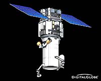
Boulder CO (SPX) Jul 31, 2007 Ball Aerospace and Technologies has successfully completed assembly and performance testing of WorldView I, the remote sensing satellite built for DigitalGlobe. Ball Aerospace, DigitalGlobe and the National Geospatial Intelligence Agency (NGA) have completed their comprehensive pre-shipment review and the satellite is being readied for delivery to California's Vandenberg Air Force Base for a mid-September launch. Ball Aerospace built the satellite bus and the WorldView 60 camera for WorldView I, the next-generation commercial remote sensing satellite. The satellite will provide unprecedented high resolution imaging capability for DigitalGlobe's customers, including the NGA and other customers around the world. Once launched, WorldView I will be the world's only half-meter commercial imaging satellite and will provide still higher resolution capability than the QuickBird satellite, currently the world's highest resolution commercial Earth imaging satellite in operation. "Ball Aerospace has worked hand-in-hand with DigitalGlobe since the mid 1990's to supply the QuickBird, WorldView I, and soon WorldView II satellites," said David L. Taylor, president and CEO of Ball Aerospace. "The constellation of commercial spacecraft created by this partnership significantly meets the increased demand for remote sensing imagery." The Control Moment Gyroscopes mounted on the WorldView I spacecraft will afford the flexibility to capture more imagery than ever before. This high spatial resolution, panchromatic imagery is used for civil government mapping, land-use planning, disaster relief, exploration, defense and intelligence, and visualization and simulation environments. For WorldView II, Ball Aerospace is building a Ball Commercial Platform 5000 spacecraft bus, and will integrate the remote sensing instrument. WorldView 2 will be ready for launch in late 2008. Ball Aerospace and Technologies Corp. supports critical missions of important national agencies such as the Department of Defense, NASA, NOAA and other U.S. government and commercial entities. The company develops and manufactures spacecraft, advanced instruments and sensors, components, data exploitation systems and RF solutions for strategic, tactical and scientific applications. Over the past 50 years, Ball Aerospace has been responsible for numerous technological and scientific 'firsts' and acts as a technology innovator for the aerospace market. Community Email This Article Comment On This Article Related Links Ball Aerospace and Technologies Earth Observation News - Suppiliers, Technology and Application
 Barcelona, Spain (ESA) Jul 31, 2007
The International Geoscience and Remote Sensing Symposium, entitled 'Sensing and Understanding our Planet,' took place from 23 to 27 July 2007 in Barcelona, Spain, bringing together more than 1400 participants. ESA personnel presented Earth Explorer missions, particularly the upcoming Soil Moisture and Ocean Salinity mission aimed at advancing our knowledge of the water cycle. |
|
| The content herein, unless otherwise known to be public domain, are Copyright 1995-2007 - SpaceDaily.AFP and UPI Wire Stories are copyright Agence France-Presse and United Press International. ESA Portal Reports are copyright European Space Agency. All NASA sourced material is public domain. Additional copyrights may apply in whole or part to other bona fide parties. Advertising does not imply endorsement,agreement or approval of any opinions, statements or information provided by SpaceDaily on any Web page published or hosted by SpaceDaily. Privacy Statement |