|
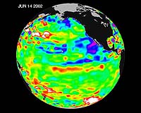
Pasadena - June 27, 2002 The Pacific Ocean doesn't show signs of anything that looks like the whopper El Ni�o of 1997-1998, according to the latest information from the U.S.-French ocean-observing satellite Topex/Poseidon. The data do show that the mid-equatorial Pacific Ocean has slowly warmed by about 1 degree Celsius (1. 8 degrees Fahrenheit) above normal in the past few months. However, the Pacific continues to be dominated by the larger-than-El Ni�o/La Ni�a pattern called the Pacific Decadal Oscillation, which may discourage El Ni�o development. "Except for some recent mid-Pacific warming, June 2002 looks very much like June 2001," said oceanographer Dr. William Patzert of NASA's Jet Propulsion Laboratory, Pasadena, Calif. "We're still in an El Ni�o holding pattern." The ocean warming in the past month can be explained by a relaxation in the equatorial trade winds observed by NASA's Quick Scatterometer (QuikScat) satellite, which measures ocean wind speed and direction. These winds usually blow from the Americas towards Asia, helping push warm water eastward. "For the first two weeks of June, these winds were unusually weak," said Dr. Timothy Liu, QuikScat project scientist. "But by last week, they had returned to normal. If the weakening continued or intensified, we could have been expecting an El Ni�o to develop by early fall." "For the past few winters the weather- and moisture-delivering jet stream has been steered north by the Pacific Decadal Oscillation and other planetary patterns, resulting in a warm winter all across the United States and very dry conditions on the East and West coasts. A large enough El Ni�o might provide some relief for the drought-plagued west, southwest and southeast U.S., but it's wishful thinking so far," Patzert added. The Topex/Poseidon data were taken during a 10-day collection cycle ending June 14, 2002. They show that there hasn't been any fundamental change in the ocean's large-scale patterns for the past three years. The near-equatorial ocean has been very quiet, although sea levels and sea-surface temperatures are near normal or slightly warmer throughout the far western and central tropical Pacific. Red areas are about 10 centimeters (4 inches) above normal; white areas show the sea-surface height is between 14 and 32 centimeters (6 to 13 inches) above normal. This warmth contrasts with the Bering Sea, Gulf of Alaska and U. S. West Coast, where lower-than-normal sea-surface levels (blue areas) and cool ocean temperatures continue. The blue areas are between 5 and 13 centimeters (2 and 5 inches) below normal, and the purple areas range from 14 to 18 centimeters (6 to 7 inches) below normal. The Pacific has settled into a negative phase of the Pacific Decadal Oscillation pattern for the past three years. This long-term ocean feature waxes and wanes approximately every 20 to 30 years. In its present phase, a warm horseshoe pattern of higher-than-normal sea-surface heights connects the north, west and southern Pacific, while a cool wedge of lower-than-normal sea-surface heights is in the eastern equatorial Pacific. Most recent National Oceanic and Atmospheric Administration sea- surface temperature data also clearly illustrate the warming of the western and central tropical Pacific and the persistence of the basin-wide Pacific Decadal Oscillation pattern. They are available at here. Community Email This Article Comment On This Article Related Links Pacific Decadal Oscillation Topex/Poseidon and Jason 1 QuikScat NOAA Seasonal Weather Forecasts SpaceDaily Search SpaceDaily Subscribe To SpaceDaily Express Weather News at TerraDaily.com
 London UK (SPX) Dec 23, 2005
This week's launch of MSG-2 will ensure that satellite images continue to be available to European weather forecasters well into the next decade. It also marks a new chapter in a long-term space experiment measuring the available energy that drives the weather as a whole, and helping to establish how much the Earth is heating up. |
|
| The content herein, unless otherwise known to be public domain, are Copyright 1995-2006 - SpaceDaily.AFP and UPI Wire Stories are copyright Agence France-Presse and United Press International. ESA PortalReports are copyright European Space Agency. All NASA sourced material is public domain. Additionalcopyrights may apply in whole or part to other bona fide parties. Advertising does not imply endorsement,agreement or approval of any opinions, statements or information provided by SpaceDaily on any Web page published or hosted by SpaceDaily. Privacy Statement |