|
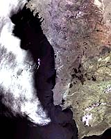
Paris (ESA) Aug 20, 2003 Fire fighters tackling the blazes that have ravaged Portugal are doing so with the aid of a satellite data-link. For the first time, ESA's satellite Artemis has been used to support an emergency request under the International Charter on "Space and Major Disasters". Portugal's civil protection unit (SNPC) was able to receive information and groups of images that showed the scope of the fires. The data, transmitted from ESA's Earth observation satellite, Envisat, via the Artemis data-relay spacecraft in geostationary orbit, were received in near real-time at the ESA data processing centre, located at ESRIN near Rome. On 4 August ESA's Earthwatching service requested a full resolution MERIS (Medium Resolution Imaging Spectrometer) acquisition over the areas in Portugal affected by the fire. The Portuguese Civil Protection then requested emergency planning on 6 August, through the Charter. The first acquisition was made via Artemis on 7 August. The Charter is an international collaboration to combine international satellite resources to assist participating rescue authorities and other civil protection agencies. ESA participates in the Charter together with Argentina , Canada, France, India and USA. In this image burnt areas appear as very dark patches to the north-east of Lisbon, close to the centre of the land part of the image, along the Tagus River. Lisbon itself is visible south of the large whitish area at the mouth of the Tagus. The image covers all of Portugal plus part of Spain's Galicia region. Use of Artemis for data relay offers Earth observation missions greater visibility and reduces delays in image reception. Artemis has been providing a data relay service to Envisat and the French national mission SPOT 4 since March of this year. Artemis is ESA's latest telecommunications satellite, designed to qualify new space technologies and promote new services. It also carries payloads for land mobile communications and a navigation payload as an element of the European Geostationary Navigation Overlay Service (EGNOS). Community Email This Article Comment On This Article Related Links Portuguese Civil Protection Artemis website Envisat website Disaster Charter Earth Watching SpaceDaily Search SpaceDaily Subscribe To SpaceDaily Express Earth Observation News - Suppiliers, Technology and Application
 New York NY (SPX) Jan 11, 2006
The importance of remotely sensed data and technologies to support natural disasters has prompted attention and action in Washington. New initiatives and legislation authorizing appropriations to the remote sensing industry will be discussed at Strategic Research Institute's U.S. Commercial Remote Sensing Industry conference, scheduled for February 9-10, 2006 in Washington D.C. |
|
| The content herein, unless otherwise known to be public domain, are Copyright 1995-2006 - SpaceDaily.AFP and UPI Wire Stories are copyright Agence France-Presse and United Press International. ESA PortalReports are copyright European Space Agency. All NASA sourced material is public domain. Additionalcopyrights may apply in whole or part to other bona fide parties. Advertising does not imply endorsement,agreement or approval of any opinions, statements or information provided by SpaceDaily on any Web page published or hosted by SpaceDaily. Privacy Statement |