|
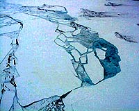
Boulder - Mar 18, 2002 Recent satellite imagery analyzed at the National Snow and Ice Data Center at the University of Colorado at Boulder has revealed that the northern section of the Larsen B ice shelf, a large floating ice mass on the eastern side of the Antarctic Peninsula, has shattered and separated from the continent in the largest single event in a 30-year series of ice shelf retreats in the peninsula. "This breakup gave us the information we need to reassess the stability of ice shelves around the rest of the Antarctic continent," said glaciologist Ted Scambos. "They are closer to the limit than we thought." The shattered ice has formed a plume of thousands of icebergs adrift in the Weddell Sea, east of the Antarctic Peninsula. A total of about 3,250 square kilometers or 1,250 square miles, of shelf area has disintegrated in a 35-day period beginning on Jan. 31 of this year. Over the last five years, the Larsen B shelf has lost a total of 5,700 square kilometers -- 2,200 square miles -- and is now about 40 percent the size of its previous minimum stable extent. Scientists worldwide have monitored the Larsen B shelf since November 2001, when a researcher at the Instituto Ant�rtico Argentino warned the community of an impending breakup in the wake of warm spring temperatures and a dramatic 20 percent increase in the ice shelf's flow rate. International cooperation between Argentinian, American, British, Austrian and German scientists has resulted in detailed information on the breakup from field observations, shipboard studies and a variety of satellite sensors. Scientists attribute the retreats to strong regional climate warming. Antarctic temperatures have increased about 2.5 degrees Celsius since the late 1940s. Since 1974 ice shelf extent in the Antarctic Peninsula has declined by about 13,500 square kilometers, or 5,200 square miles. Scambos and colleagues Mark Fahnestock at the University of Maryland and Christine Hulbe of Portland State University have theorized that once melt water appears on the surface, the rate of ice disintegration increases. They say melt water ponding on the surface in late summer magnifies fracturing by filling smaller cracks. From there, Scambos said, the weight of the water drives the cracks through the ice, making it shatter. "The next shelf to the south, the Larsen C, is very near its stability limit, and may start to recede in coming decades if the warming trend continues," he said. "More importantly, regions of the giant "Ross Ice Shelf are just a few degrees Celsius away from being overtaken by the same processes that have destroyed the Larsen." Ice shelves are thick plates of ice, fed by glaciers, that float on the ocean around much of Antarctica. The Larsen B was about 220 meters thick. Based on studies of shelf ice flow and sediment thickness beneath the ice shelf, the Larsen B is thought to have existed for at least 400 years prior to current events. The breakup of peninsular ice shelves has little direct consequence for sea-level rise. However the shelves act as buttresses, or braking systems, for glaciers on the continent. "Loss of ice shelves surrounding the Antarctic continent could have a major effect on the rate of ice flow off the continent," Scambos said. "The Ross ice shelf for instance, is the main outlet for the West Antarctic Ice Sheet, which encompasses several large glaciers and contains the equivalent of 5 meters of sea level in its perched ice." Community Email This Article Comment On This Article Related Links Antarctic Ice Shelves SpaceDaily Search SpaceDaily Subscribe To SpaceDaily Express Dirt, rocks and all the stuff we stand on firmly
 Paris (ESA) Jan 12, 2006
Using the ESA Cluster spacecraft and the NASA Wind and ACE satellites, a team of American and European scientists have discovered the largest jets of particles created between the Earth and the Sun by magnetic reconnection. This result makes the cover of this week's issue of Nature. |
|
| The content herein, unless otherwise known to be public domain, are Copyright 1995-2006 - SpaceDaily.AFP and UPI Wire Stories are copyright Agence France-Presse and United Press International. ESA PortalReports are copyright European Space Agency. All NASA sourced material is public domain. Additionalcopyrights may apply in whole or part to other bona fide parties. Advertising does not imply endorsement,agreement or approval of any opinions, statements or information provided by SpaceDaily on any Web page published or hosted by SpaceDaily. Privacy Statement |