|
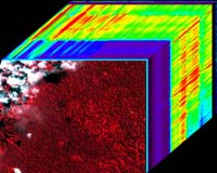
Stanford CA - Apr 07, 2004 Using a unique combination of ground-based and space-based tools, scientists have determined for the first time how drought conditions, and possibly carbon uptake, in the Amazon rainforest can be quantified over large forest areas from space. The results are published in the on-line early edition of the Proceedings of the National Academy of Sciences, April 5-9. "Understanding the Amazon environment is an essential puzzle piece needed to understand how the biosphere interacts with the climate system," said lead author Dr. Gregory Asner of the Department of Global Ecology at the Carnegie Institution in Stanford, California. "The Amazon is simply too big and complex to study on the ground alone," he continued. "Thus far it's been impossible to determine some of the most basic properties of the forest that we need in order to understand what happens during common climatic events--such as the El Ni�o dry periods--and what that means to forest growth and the amount of carbon that is locked up in the forest via photosynthesis. "Without these measurements we will fall short in understanding how large a role tropical forests play in mediating the effects of fossil-fuel emissions from human activities." Amazonia, the world's largest rainforest, experiences a big range in rainfall from the rainy to dry seasons and during global climatic events such as El Ni�o. The amount of precipitation affects forest dynamics, land use, and fire susceptibility. To evaluate drought conditions the researchers conducted the first forest canopy experiment in the region. They covered over 10,000 square meters of the central Brazilian Amazon forest with plastic making a "drydown" site and then measured rainfall, soil moisture, leaf and canopy characteristics over time. They coupled these data with a new space-based technology called imaging spectroscopy from the NASA Earth Observing-1 (EO-1) satellite launched in November of 2000. They found that the spectra collected by the satellite from reflected sunlight correlates with on-ground measurements indicating a decrease in soil water and dehydrated leaves. "The fact that we confirmed that satellite imaging can be used to measure something as detailed as the physiology of the rainforest canopy, means that this technique might be useful for understanding other types of ecological phenomena at both large and small scales," Asner remarked. " We believe that space-based technology like this is the wave of the future for analyzing our planet, " he concluded. Community Email This Article Comment On This Article Related Links Global Ecology at Carnegie/Stanford SpaceDaily Search SpaceDaily Subscribe To SpaceDaily Express Earth Observation News - Suppiliers, Technology and Application
 New York NY (SPX) Jan 11, 2006
The importance of remotely sensed data and technologies to support natural disasters has prompted attention and action in Washington. New initiatives and legislation authorizing appropriations to the remote sensing industry will be discussed at Strategic Research Institute's U.S. Commercial Remote Sensing Industry conference, scheduled for February 9-10, 2006 in Washington D.C. |
|
| The content herein, unless otherwise known to be public domain, are Copyright 1995-2006 - SpaceDaily.AFP and UPI Wire Stories are copyright Agence France-Presse and United Press International. ESA PortalReports are copyright European Space Agency. All NASA sourced material is public domain. Additionalcopyrights may apply in whole or part to other bona fide parties. Advertising does not imply endorsement,agreement or approval of any opinions, statements or information provided by SpaceDaily on any Web page published or hosted by SpaceDaily. Privacy Statement |