|
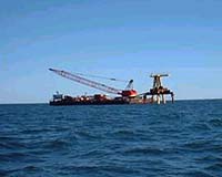
Edgartown - Oct 11, 2002 In the deep waters two miles south of Edgartown on Martha's Vineyard, not far from where, two centuries ago, the likes of Captain Ahab and a thousand others kept their watch for the great white and his kin, we are now searching to understand another potential beast in those parts: the ocean and the weather. But this is no allegory. Hoping to avoid any recurrence in these sometimes turbulent waters of the horrendous storms so intensely portrayed in Moby Dick as well as The Perfect Storm, the Office of Naval Research has built a tower bristling from top to bottom with sensors. The Air-Sea Interaction Tower will continually measure atmospheric and ocean conditions such as air temperature, humidity, solar radiation and carbon dioxide, as well as water temperature, salinity or salt content, wave height and direction, water circulation, current speed and direction, and sediment transport. It will directly measure momentum, heat, and mass exchange between the atmosphere and ocean. Anchored 50 feet down into the ocean floor, the tower extends 76 feet into the marine atmosphere. It will be maintained and operated by scientists at the Woods Hole Oceanographic Institution (WHOI) in Massachusetts and will be connected by undersea cables to WHOI's Martha's Vineyard Coastal Observatory (MVCO). "No one has ever built this kind of thing before. Understanding how the ocean and atmosphere interact under all conditions, and understanding the factors that affect the exchange of energy between the ocean and atmosphere, how readily carbon dioxide is exchanged, and how currents and waves affect bottom sediments, makes for better weather forecasts," says science officer Simon Chang who oversees the project for ONR. "Avoiding storms and correctly and precisely forecasting bad weather saves lives." Power and data transmission from the Tower are supplied the underwater cable linked to MVCO. Data gathered will be integrated with MVCO data and made directly available to all users and to the general public via the MVCO web site. The data will include wind speed and direction, air and sea temperature, wave height and direction, and currents at the offshore site. "This is a one-of-a kind platform for studying coastal processes in the Atlantic Ocean," says James Edson of WHOI's Ocean Physics and Engineering Department, who serves as project engineer. "It will be used by researchers, educators, and students from around the world during its lifetime." Ishmael told a good story, but unlike his Captain he did not vow a relentless watch, and a relentless watch is what the Navy wants. Better to call this tower, Ahab. Community Email This Article Comment On This Article Related Links Martha's Vineyard Coastal Observatory Office of Naval Research SpaceDaily Search SpaceDaily Subscribe To SpaceDaily Express Dirt, rocks and all the stuff we stand on firmly
 Paris (ESA) Jan 12, 2006
Using the ESA Cluster spacecraft and the NASA Wind and ACE satellites, a team of American and European scientists have discovered the largest jets of particles created between the Earth and the Sun by magnetic reconnection. This result makes the cover of this week's issue of Nature. |
|
| The content herein, unless otherwise known to be public domain, are Copyright 1995-2006 - SpaceDaily.AFP and UPI Wire Stories are copyright Agence France-Presse and United Press International. ESA PortalReports are copyright European Space Agency. All NASA sourced material is public domain. Additionalcopyrights may apply in whole or part to other bona fide parties. Advertising does not imply endorsement,agreement or approval of any opinions, statements or information provided by SpaceDaily on any Web page published or hosted by SpaceDaily. Privacy Statement |