 |
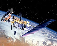
Sunnyvale CA (SPX) Mar 24, 2009 The NOAA-N Prime spacecraft, the final Polar Operational Environmental Satellite (POES) launched on Feb. 6, 2009, has completed a comprehensive 45-day on-orbit verification period. Lockheed Martin built NOAA-N Prime at its Space Systems Company Sunnyvale facility. The new satellite, designated NOAA-19 when it reached orbit, is the final spacecraft in the TIROS series. All have been designed and built for the National Aeronautics and Space Administration (NASA) by Lockheed Martin since the first Television and Infrared Observational Satellite (TIROS) weather satellite launch in April 1960. NASA managed the spacecraft's launch and the National Oceanic and Atmospheric Administration (NOAA) operates the satellite in space. Over many years of service, TIROS satellites have earned the reputation as the workhorses of the Civil Space Earth-imaging inventory. "We are very pleased to learn that NOAA-19 has passed this important milestone," said Jeff Vanden Beukel, Lockheed Martin TIROS program director. "For several decades the Lockheed Martin team has been totally dedicated to providing NASA with a series of satellites that extend NOAA's ability to provide uninterrupted environmental data products to users. Working together with our NASA and NOAA partners has, and will always remain, a source of enormous pride for Lockheed Martin." A constellation consists of one MetOp - a European meteorology satellite - and one POES satellite circling the planet in nearly north-south orbits. As the Earth rotates, the entire globe, one swath at a time rolls into view of the satellites' instruments. The satellites provide measurements of reflected solar and radiated thermal energy from land, sea, clouds and the atmosphere in the visible, microwave and infrared spectrum, atmospheric soundings of temperature and humidity, measurements of global sea surface temperature, aerosol distribution data, ozone concentration data, soil moisture data, and measurements of orbital proton and electron flux. Additionally, POES satellites collect data from remote platforms, relay search and rescue data, and also provide direct broadcast of environmental data worldwide. Data from the spacecraft support a broad range of environmental monitoring applications including weather analysis and forecasting, climate research and prediction, ocean dynamics research, volcanic eruption monitoring and forest fire detection. Together these data comprise irreplaceable inputs to the numerical weather forecast model and are vital to medium and long-range forecasting. Separately or in combination, the data are utilized to produce sea-surface temperature maps, ice condition charts, vegetation maps and other forecasting and management tools. The NOAA-19 spacecraft is 13.75 feet long by 6.2 feet in diameter, and weighs 3,130 pounds at liftoff. Its solar array has 180.6 square feet of surface area and generates 833 watts at a zero degree sun angle. The instruments onboard NOAA-19 were provided by NASA and NOAA, and include the Advanced Very High Resolution Radiometer (AVHRR/3), the High Resolution Infrared Radiation Sounder (HIRS/4), the Advanced Microwave Sounding Unit A (AMSU-A), the EUMETSAT-supplied Microwave Humidity Sounder (MHS), the Solar Backscatter Ultraviolet Spectral Radiometer/2 (SBUV/2), the Space Environment Monitor/2 (SEM/2) and the Advanced Data Collection System (A-DCS). In addition, NOAA-19 carries two search and rescue instruments, the Search and Rescue Repeater (SARR) and the Search and Rescue Processor (SARP) that are used internationally for locating ships, aircraft, and people in distress. The use of satellites in search and rescue has been instrumental in saving more than 24,500 lives since the inception of the Search and Rescue Satellite-Aided Tracking (SARSAT) system. Spacecraft launch site processing at Vandenberg Air Force Base (VAFB) included end-to-end testing with the Satellite Operations Control Center in Suitland, Md., final spacecraft electrical testing and spacecraft inspections. The NOAA-19 spacecraft was launched from the Western Range Space Launch Complex-2 at VAFB, by a two-stage United Launch Alliance Delta II 7320-10C space launch vehicle. NASA's Goddard Space Flight Center, in Greenbelt, Md., was responsible for the procurement, development, launch services, and verification of the spacecraft, instruments, and unique ground equipment. Following spacecraft launch, Goddard was responsible for satellite health and safety during a comprehensive on-orbit verification period that lasted 45 days. Following satellite checkout, NASA turned operational control over to NOAA. NOAA will operate the satellite from the Satellite Operations Control Center along with the nation's other environmental satellites. The NOAA-19 satellite operates in a circular, near-polar orbit of 464 nautical miles above the Earth with an inclination angle of 98.73 degrees to the equator. Its orbital period - the time it takes to complete one orbit of the Earth - is approximately 102.14 minutes. The NOAA-19 orbit is Sun-synchronous, rotating eastward about the Earth's polar axis 0.968 degrees each day, approximately the same rate and direction as the Earth's average daily rotation about the sun. The rotation keeps the satellite in a constant position with reference to the sun for constant scene illumination throughout the year. Share This Article With Planet Earth
Related Links Lockheed Martin Space Technology News - Applications and Research
 London, UK (SPX) Mar 10, 2009
Surrey Satellite Technology has delivered to the customer, FSUE NPP VNIIEM, the first two suites of equipment for the KANOPUS-type satellite platforms. |
|
| The content herein, unless otherwise known to be public domain, are Copyright 1995-2007 - SpaceDaily.AFP and UPI Wire Stories are copyright Agence France-Presse and United Press International. ESA Portal Reports are copyright European Space Agency. All NASA sourced material is public domain. Additional copyrights may apply in whole or part to other bona fide parties. Advertising does not imply endorsement,agreement or approval of any opinions, statements or information provided by SpaceDaily on any Web page published or hosted by SpaceDaily. Privacy Statement |
 del.icio.us
 Digg
Digg Reddit
 YahooMyWeb
 Google