|
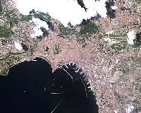
Paris, France (SPX) May 18, 2006 ESA has for the first time acquired and processed images sent by ALOS ďż˝ Japan's four-ton satellite dedicated to land-based Earth observation ďż˝ including views of Italy, the Netherlands and Norway. ESA is utilizing its facilities and expertise to acquire, process and distribute data from the satellite. "We have received high-quality data from ALOS, and our team has worked extremely hard and done a great job acquiring and processing the images,ďż˝ said Bianca Hoersch, ESA's third-party mission manager. ALOS captured the image above of Naples, Italy, with its Advanced Visible and Near Infrared Radiometer type-2, designed to chart land cover and vegetation in visible and near infrared spectral bands. The satellite also captured images of the Netherlands and Norway using its Phased Array type L-band Synthetic Aperture Radar ďż˝ a microwave radar instrument that can acquire observations during both day and night and through any weather conditions. ALOS acquired the images on April 28 and May 1 at Kiruna Esrange, the downlink station operated by Sweden's SSC, and they were processed at ESRIN, ESA's Earth observation center in Frascati, Italy. In addition to these instruments, ALOS also carries the Panchromatic Remote-sensing Instrument of Stereo Mapping, which can observe selected areas in three dimensions, down to a 2.5 meter spatial resolution. ALOS, which was delivered into a 700 kilometer (435 mile) polar orbit on last Jan. 24 from the Tanegashima Space Center in Japan, is continuing its nine-month commissioning phase. Based on a cooperative agreement with JAXA, ESA is hosting the ALOS European Data Node, delivering near-real time and offline data to scientific and operational users across Europe and Africa. ESA has set up a commissioning phase ground segment for ALOS with Kiruna Esrange. Data from Kiruna is transferred electronically to ESRIN and processed in a shared arrangement between ESRIN and the Neustrelitz Station, located in Germany and operated by DLR. ESA will continue to test the ground segment chain from acquisition to archiving, processing and distribution with more regular downlinks scheduled to begin in late May. In addition to receiving data directly from ALOS, ESA will start to receive data offline from JAXA via media at the same time. The data volume is estimated to be around 200-250 gigabytes daily, covering the ADEN zone. When ALOS enters its operational phase later this year, ESA will set up a larger ground segment with various acquisition stations and archives to provide optimal coverage over Europe. Operational ALOS data distribution from ESA will begin next November. The agency's announcement of opportunity for scientific use of ALOS data already has received 150 proposals, with 139 coming from ESA members, requesting a total of 26,000 ALOS products along with 14,000 products from ESA's ERS-2 and Envisat satellites, as well as other third-party missions. "Regular Category-1 data access ďż˝ requested by scientists for further research projects ďż˝ will be open at reproduction cost to the scientific and pre-operational user community for proposal submission from July," Hoersch said. Operational and commercial users will be able to receive ALOS data via commercial distribution schemes. ALOS data also will be available for Global Monitoring for Environment and Security, the joint initiative by ESA and the EU to develop an independent environmental monitoring capability for Europe. Community Email This Article Comment On This Article Related Links ALOS ESA Earth Observation News - Suppiliers, Technology and Application
 Greenbelt MD (SPX) May 17, 2006
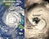
Scientists at NASA are finding that with hurricanes, they can look at the cloud tops for clues about the behavior of winds below the hurricane on the Earth's surface. By looking at how high up the rain is forming within clouds, scientists can estimate whether the hurricane's surface winds will strengthen or weaken. |
|
| The content herein, unless otherwise known to be public domain, are Copyright 1995-2006 - SpaceDaily.AFP and UPI Wire Stories are copyright Agence France-Presse and United Press International. ESA PortalReports are copyright European Space Agency. All NASA sourced material is public domain. Additionalcopyrights may apply in whole or part to other bona fide parties. Advertising does not imply endorsement,agreement or approval of any opinions, statements or information provided by SpaceDaily on any Web page published or hosted by SpaceDaily. Privacy Statement |