|
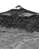
Paris, France (SPX) Feb 16, 2006 This image of Mt. Fujiyama has been compiled from the first data acquired by Japan's Advanced Land Observing Satellite, or ALOS, which was launched on Jan. 24. ESA is supporting ALOS as a Third Party Mission, meaning the space agency is using its ground systems and expertise to acquire, process and distribute data from the satellite to users. At an elevation of 3,776 meters (12,388 feet), Mt. Fuji is Japan's highest mountain. A volcano that has been dormant since its last eruption in 1707, it is located near the southern coast of the main island of Honshu and straddles the prefectures of Yamanashi and Shizuoka about 100 kilometers (65 miles) west of Tokyo. The front of the image displays detailed streets and rivers in the Kofu Basin, and Motosu Lake - one of five lakes making up the Fuji Five Lake region - is in the center right. The Fuji-Subaru road, which leads to the top of the mountain from Motosu Lake, can also be seen. Motosu Lake, featured on Japan's 5000-yen note, is the westernmost of the five lakes, all of which were formed by lava flows. It has a circumference of 13 kilometers (8 miles). The other four lakes are Kawaguchi, Yamanaka, Sai and Shoji. Thousands of people ascend Mt. Fuji every year, usually during July and August - the official climbing season - when there is no snow. The mountain hike is divided into 10 stations, with paved roads going to the fifth station, around 1,400 to 2,400 meters (about 4,600 feet to 7,900 feet) above sea level. ESA acquired the image data as part of the first functional verification test since the satellite's launch. The Panchromatic Remote-sensing Instrument for Stereo Mapping, or PRISM - one of the three instruments on board ALOS - observed the mountain on Feb. 14. The PRISM is an optical sensor, with three independent optical systems for acquiring terrain and altitude data simultaneously, allowing for three-dimensional images with a high accuracy and frequency. The other two instruments are the Phased Array type L-band Synthetic Aperture Radar, or PALSAR - a microwave radar instrument that can acquire observations through any weather conditions - and the Advanced Visible and Near Infrared Radiometer type-2. or AVNIR-2, designed to chart land cover and vegetation in visible and near-infrared spectral bands. Community Email This Article Comment On This Article Related Links ALOS ESA Earth Observation News - Suppiliers, Technology and Application
 Paris, France (SPX) Feb 20, 2006
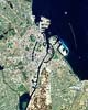
This Proba image shows the historic port of Copenhagen, the capital of Denmark for the last 600 years. Appearing off the coast like a string of pearls is a 21st Century addition to the city: one of the largest offshore wind farms in the world. |
|
| The content herein, unless otherwise known to be public domain, are Copyright 1995-2006 - SpaceDaily.AFP and UPI Wire Stories are copyright Agence France-Presse and United Press International. ESA PortalReports are copyright European Space Agency. All NASA sourced material is public domain. Additionalcopyrights may apply in whole or part to other bona fide parties. Advertising does not imply endorsement,agreement or approval of any opinions, statements or information provided by SpaceDaily on any Web page published or hosted by SpaceDaily. Privacy Statement |